


By John Ikani
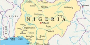
Plans have been concluded by the Federal Government of Nigeria to review the current map of Nigeria, which was produced by the Canadian Government in 1970.
This was made known by the Acting Surveyor-General of the Federation (SGoF), Abduganiyu Adebomehin while defending the 2020 budget appropriation before the House Committee on Works and Housing at the National Assembly Complex, Abuja.
According to Adebomehin, the current Nigerian map was produced for the country 51 years ago, and needed to be updated to support environment, physical infrastructure and socio-economic system and guarantee sustainable development.
The Acting Surveyor-General explained that the planned review would enable the country have a new map to successfully deal with various negative challenges working against the commitment and efforts of the government towards achieving more effective security network.
He went on to note that the country would continue to find it difficult to make effective decisions, plan well and successful implement or execute its people-oriented and developmental projects without current topographical sheets that could provide timely and reliable data.
Adebomehin who identified poor funding as one of the constraints hindering production of current topo-sheets, lamented that paucity of funds also hinders the provision of a good number of Continuously Operating Reference Station (CORS) across the country as well as limit maximization of high performance data centre.
The Ag. SGoF further explained it would require a drone that could fly for certain period of time to generate data for a complete topo-sheet, assuring, if properly funded the project could provide the necessary support to enhance the country’s Internally Generated Revenue (IGR).
Responding, Chairman, House Committee on Works and Housing Abubakar Abubakar, acknowledged the relevance of the office of the SGoF and requested its leadership to provide the committee critical documents for more information for better appropriation.


